Last Updated on 15th February 2026 by admin
Have you ever wished that you could travel around the world and be in several different places at the same time in just a few minutes–all without having to step inside a plane? At Klejtrup Lake in Denmark this dream comes true. The world is filled with famous tourist destinations that you might have seen or heard through social media, blogs, or even, via your contacts, friends, and family. In this article, however, we are discovering a rather rare and obscure destination that you may not be familiar with.
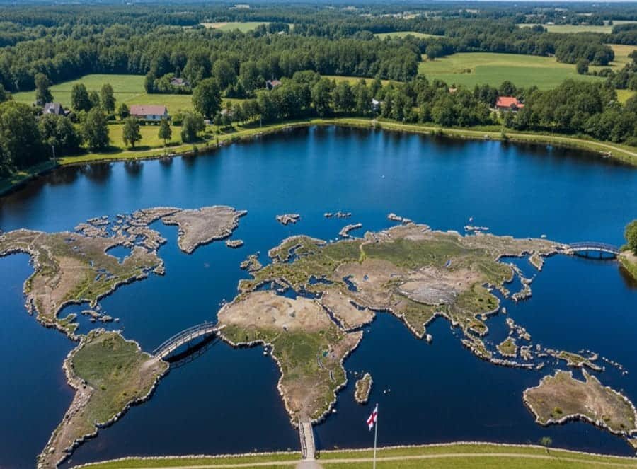
Welcome to the exceptional destination as to delve into this place, you will not only enjoy learning about it but may also become surprised by its story and marvel. World Map at Klejtrup Lake, locally known as Verdenskortet, an extraordinary example of a sculpture park and one-of-a-kind destination, where the visitor can discover a detailed miniature world in the Danish landscape.
A Hidden Gem in the Heart of Denmark
Located just outside of the town of Hobro in northern Jutland, the World Map at Klejtrup Lake is one of the most famous attraction sites in Denmark. It is not merely a map, but the masterpiece of passion, dedication and creativity. The park attracts tourists of different calibers all over the world and wonders at the precision, size, and the amount of work it took to create this giant outdoor world map.
The Story Behind the Map: A Farmer’s Vision
This world map was the life work of Soren Poulsen who was a Danish farmer who came back to Denmark in 1940s after returning in the United States. In 1944, at one of his working places around Klejtrup Lake he discovered a stone in the shape of a peninsula Jutland. This discovery made him begin to create an entire miniature world map, with the help of rocks, soil, and natural materials.
Over 25 years, through cold Danish winters and sun filled summers, Poulsen laboriously laid down stones and sculpted coastlines using his own hands. His imagination made up a miniature-sized model of the world along with 90 meters and 45 meters in length and width and created it with precision and zeal.
What to Expect: Walk Across Continents
Visitors can literally walk from Europe to North America, cross the Pacific Ocean, and hop down to Australia, all within a few minutes. This isn’t just an exhibit—it’s an interactive and educational experience for all ages.
Key Highlights of Verdenskortet:
- Accurate scale: The distance between latitudes is 111 kilometers per a degree of latitude.
- Realistic landforms: continents and nations are made with stones, grass, and natural materials.
- Seas and lakes: Represented with small water channels filled from the nearby Klejtrup Lake.
- Miniature flags: Mark many countries, making it easy to spot your favorite destination.
- Informational signs: Present information to students, tourists, and geography fans.
Perfect for Families, Schools, and Explorers
The World Map in the Klejtrup Lake is not only a viewing point. It is an open-air school and the ideal location of family picnics, excursions and nature outings. Children enjoy the practical parts of it and grown-ups are glad to see the beautiful country and take pictures.
As well as a visitor center, a cafe to enjoy, and a playground as well to keep the young ones occupied, it makes it a day trip with something to do to satisfy everyone.
Practical Information for Visitors
- 📍 Location: Klejtrup Søvej 26, 9500 Hobro, Denmark
- ⏰ Open: Typically from April to October (check official website for seasonal hours)
- 💳 Entry Fee: Affordable family tickets available
- 🍴 Amenities: Café, picnic spots, restrooms, gift shop
Why You Should Visit the World Map at Klejtrup Lake
This is great place to visit in northern Jutland or unusual places in Denmark, especially when you are planning a trip to Denmark. The combination of natural beauty, handmade topography and history make the World Map at Klejtrup Lake one of the most distinctive places in Europe.
History lovers, avid travelers, or families on vacation; get a surprise and become impressed with the detail and allure of this world map. It symbolizes what human will can accomplish and it is a very powerful testimony that when we see clear vision and we work towards its fulfillment we can indeed make the world.