Last Updated on 14th April 2026 by admin
There are places on the earth that are not real. When you see them in photos, they often appear edited or computer-generated. But these landscapes are actually exist and this is what makes them so fascinating. Some of them are formed by extreme climatic conditions and others are formed by some geological processes.
These places have been referred to as unreal places on earth due to their appearance, which is completely different to the normal landscapes. These locations are even more fascinating because of their dissimilarity.
In this article, we will explore places on Earth that don’t look real, highlighting destinations that feel unusual, unexpected, and almost otherworldly.
1. Socotra Island
Location: Yemen
Known for: Dragon Blood Trees and unique biodiversity

The Socotra Island is commonly referred to as the most alien looking place on Earth and the description seems to be true the moment you see it. There are strange trees and plants in the landscape which are completely different as compared to the rest of the landscape. Socotra Island is one of the most unique places on earth, with features that cannot be found anywhere else.
The island is best known for its Dragon Blood Trees, which have a distinctive umbrella shape. These are not only beautiful, but also rare and almost impossible to be found elsewhere. In fact, a large percentage of the plant species on Socotra are endemic, meaning they exist only on this island.
Another interesting detail is how isolated the island is. Because of its remote location in the Arabian Sea, Socotra developed its own ecosystem over millions of years. It is this isolation that makes the island so special and untouched.
Socotra Island stands out not just because it looks different, but it shows how different and unexpected nature may be when it is left alone over a long period of time.
2. Atacama Desert
Location: Northern Chile
Known for: Being the driest non-polar desert on Earth
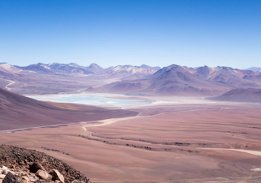
Atacama Desert is among the driest regions on earth, and some weather stations have not received any rain in several decades. This extreme dryness is caused by a combination of factors, including the cold Humboldt Current and surrounding mountain ranges that block moisture.
The landscape here is very different from typical deserts. Instead of large sand dunes, you will find salt flats, rocky terrain, and areas such as Valle de la Luna, where the surface shows conditions similar to those studied in planetary research. Because of this, parts of the Atacama are often used to test equipment for space missions.
The Atacama Desert is often listed among the famous deserts in the world due to its extreme climate and scientific importance. There is a extremely limited water, and even survival is depends to the management of the available resources. In some regions, the moisture of the fog is harvested with the help of special nets and it supplies some local communities with a small yet necessary amount of water.
Due to the lack of humidity and almost no cloud cover, it is considered one of the best places in the world for astronomical observation. It is home to several large observatories and some of the best telescopes that are in operation today. The Atacama desert demonstrates how life and science adjust to one of the most harsh on Earth environments.
3. Salar de Uyuni
Location: Bolivia
Known for: Largest salt flat with mirror-like reflections
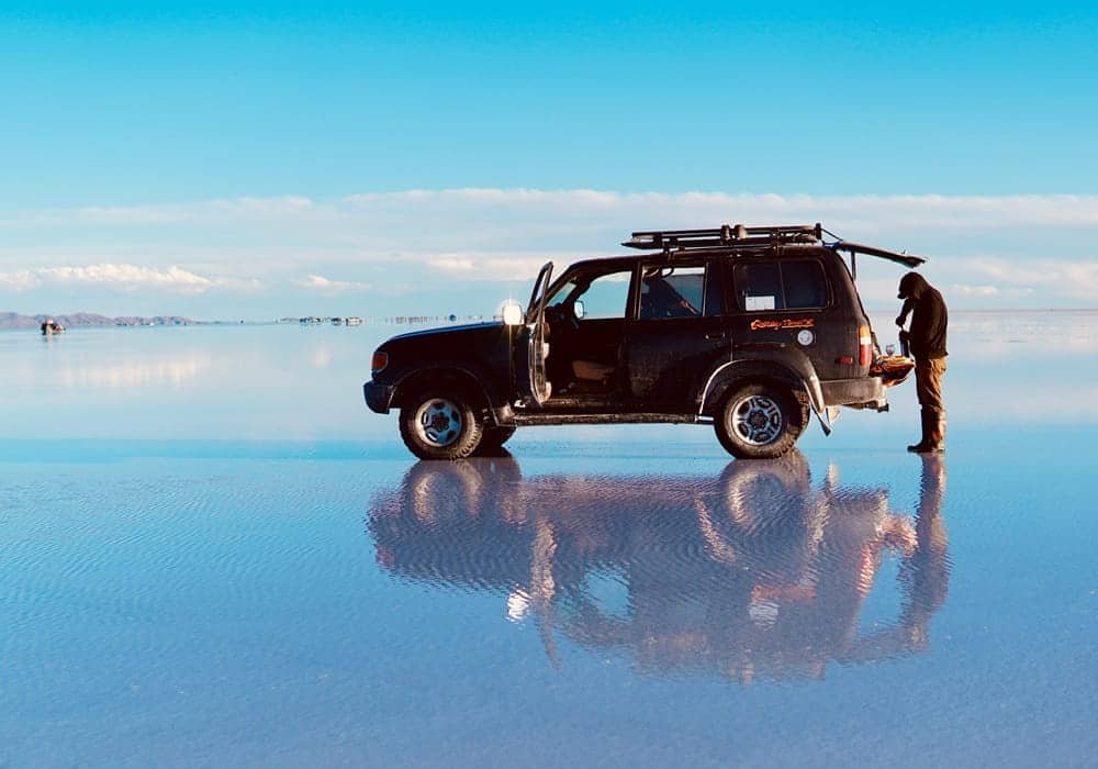
Salar de Uyuni is the largest salt flat in the world, covers more than 10,000 square kilometers and was formed from the evaporation of prehistoric lakes. With time, layers of salt formed a thick, flat layer that now covers the area. Surface pattern is one of the unique aspects.
The salt is shaped as natural hexagons because of the repeated cycles of expansion and contraction. These patterns can be seen across large areas and are a result of physical processes rather than human activity. During the wet season, a thin layer of water collects on the surface. This gives a reflective effect wherein the sky seems to be mirrored on the ground.
It is one of the rare locations where the perception of depth can be changed as the horizon becomes hard to recognize. Under the salt crust, there are also large reserves of lithium in the area. This resource is important for battery production and has increased the global importance of the region in recent years.
There are also small islands within the salt flat, such as Incahuasi Island, which is covered with large cacti. These islands are part of old volcanoes and they contrast the otherwise flat land. Salar de Uyuni shows how landscapes can be formed by geological processes that can make them look strange yet being absolutely natural.
4. Wadi Rum
Location: Southern Jordan
Known for: Sandstone mountains, red sand valleys, and rock formations
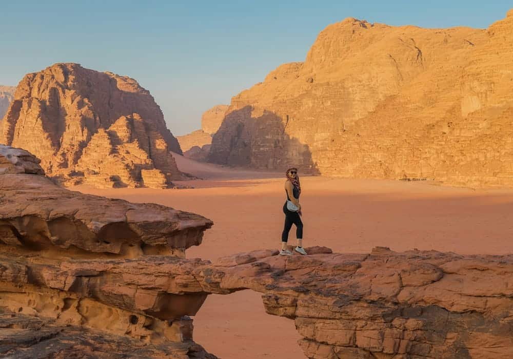
Wadi Rum is a desert valley with large masses of sandstones and granites that emerge sharply out of the earth. This is in contrast to the normal flat deserts because this area has cliffs, narrow canyons and natural rock arches that have been created due to erosion over a long period of time.
Wadi Rum has also been used as a filming location for several movies due to its terrain, which resembles Martian landscapes. The sand is red due to the presence of iron oxide that gives the landscape a unique appearance. This geological formation together with landscape formation has given the Wadi Rum a scientific and visual attraction.
The area has been inhabited for thousands of years, and ancient petroglyphs can still be found carved into rock surfaces. These carvings provide evidence of early human activity and cultural history in the region. However, its features are entirely natural and formed through geological processes, making it a suitable location for observing stars and constellations.
Wadi Rum shows that desert landscapes do not just consist of open sand, but can also contain intricate geology. Some of these landscapes are even compared to places that look like another planet due to their extreme conditions.
5. Zhangjiajie National Forest Park
Location: Hunan Province, China
Known for: Tall sandstone pillars and vertical landscapes
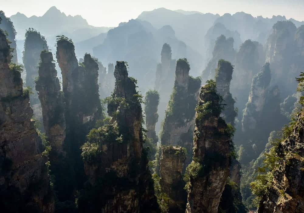
Zhangjiajie National Forest Park is known for its tall and narrow sandstone pillars, which come out of the ground with a sharp angle. These formations were formed over millions of years by erosion, whereby the softer rock wore away and left these vertical structures.
The pillars can reach heights of more than 200 meters and are often covered with vegetation. Mist frequently surrounds the area, which makes the peaks appear as if they are floating. This amazing visual effect has made the location widely recognized for its unique appearance.
The landscape is neither flat nor a plain, it is rather made up of dense forests, sharp rocks, and deep valleys. This creates a layered landscape where visibility changes depending on weather conditions and elevation. Similar dramatic terrain can also be seen at Heaven Gate, where steep cliffs and high-altitude formations shape the landscape.
The area is also home to a wide range of plant and animal species. The fact that there is a difference in altitude and climate in a fairly small area supports biodiversity within its environment. Zhangjiajie shows that the vertical landforms may be formed as long-term geologic processes create a striking contrast to the normal mountain or forest environment.
6. Antelope Canyon
Location: Arizona, United States
Known for: Narrow sandstone slot canyons and light beams
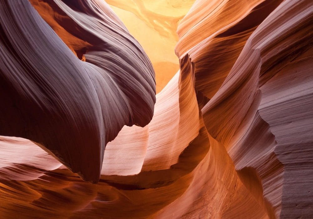
Antelope Canyon is a slot canyon formed by the erosion of sandstone over thousands of years. The narrow passages were carved over time by flash floods and flowing water, forming smooth, curved walls that had layered patterns.
The entry of light into this canyon is one of the most distinctive aspects of this canyon. During some days of the year, the sun rays come through the small holes in the sky above and form visible rays within the canyon. These are only temporary light beams that are reliant on the sun position.
The canyon consists of two major parts, which are Upper and Lower Antelope Canyon. The Upper section is broader at the top and has more direct sunlight and the Lower one is smaller and requires one to walk through narrower areas.
The surface of the rock shows different shades of orange, red, and brown. Such colors are the outcome of mineral deposits in the sandstone, which emerge more in the light changing conditions. Antelope Canyon exemplifies how water and time can make a rock complex, even in a dry desert landscape.
7. Pamukkale
Location: Denizli, Turkey
Known for: White travertine terraces and thermal mineral pools
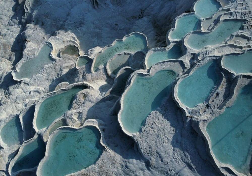
Pamukkale is a natural formation created by mineral-rich thermal waters flowing down a hillside over thousands of years. As the water moves, it deposits calcium carbonate, which gradually builds up into solid layers. These layers form a series of terraces that look like steps or shallow pools arranged across the slope.
The water of these terraces is warm and in constant motion though it might seem at first glance that it does not move. When it cools it leaves behind more mineral deposits, slowly reshaping the surface. This is a continuous process and therefore, the landscape is continuously evolving over time.
One of the most noticeable features of Pamukkale is its bright white color. The calcium deposits reflect light strongly, making the terraces stand out against the surrounding environment. The difference is even more visible during the sunrise and sunset when the light changes the look of the surface.
People have been visiting this area for centuries, mainly because of the warm pools and their perceived benefits. Pamukkale is one such example of how natural processes, including mineral deposition and water flow, can be used to form structured and long-lasting landscapes without direct human involvement.
8. Lake Hillier
Location: Western Australia
Known for: Naturally pink-colored water
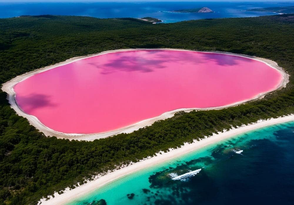
Lake Hillier is a salty lake found on the Middle Island and it is well known due to its pink color. Unlike many other colored lakes, its color remains consistent throughout the year and does not change significantly with weather conditions.
The pink color is believed to be caused by a combination of microorganisms, including algae and bacteria that thrive in high-salinity environments. These organisms generate pigments that make the water look strange.
One notable aspect of Lake Hillier is the contrast it creates with its surroundings. The bright pink water sits next to deep blue ocean water, separated by a narrow strip of land. This contrast enhances the visual uniqueness of the lake, especially when viewed from above.
The lake is quite small, about 600 meters in length, but the lake has become famous because of its image. Despite its unusual color, the water is not harmful, although access to the island is limited to protect the environment.
Lake Hillier shows how biological activity in extreme conditions can influence the appearance of natural landscapes in unexpected ways.
9. Grand Prismatic Spring
Location: Wyoming, United States
Known for: Multicolored geothermal hot spring
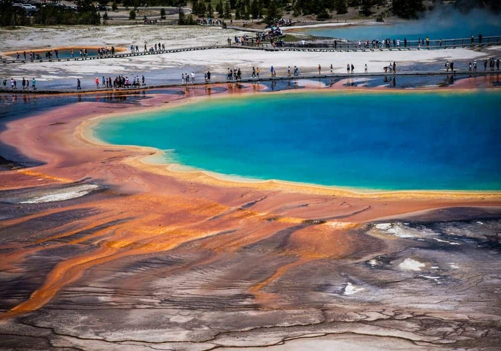
Grand Prismatic Spring is the biggest hot spring in the United States and one of the most well-known geothermal features in the world. It is known for its bright colors, which form rings around the central pool.
It is because of the purity of the hot water that the center of the spring is deep blue. When the water flows outwards and cools, other kinds of heat-loving microorganisms develop along the sides. The pigments formed by these microorganisms give them yellow, orange, and red bands.
The water temperature differs throughout the spring and this directly influences the extent to which certain organisms can survive. This produces a natural gradient of colors which makes the spring look layered when looking at it above.
Another constant is steam which is rising through the surface. It develops when the hot water collides with the cooler air, and in some cases, it partially obscures the view, and alters the appearance of the colors at various points of time during the day.
Grand Prismatic Spring illustrates that combination of temperature, water chemistry and microbial life can collaborate to produce a highly structured and visually distinct natural structure.
10. Mount Roraima
Location: Venezuela, Brazil, and Guyana
Known for: Flat-topped mountain (tepui) and isolated ecosystem
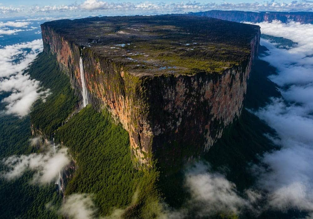
Mount Roraima is one of the oldest and geological formations on earth and is estimated to be around two billion years old. It belongs to a group of mountains known as tepuis, which are characterized by flat tops and steep vertical cliffs. The summit of Mount Roraima is isolated from the surrounding land due to its height and structure.
Over time, unique plant and animal species have developed here, many of which are not found anywhere else. Mount Roraima is partially located within Canaima National Park, a region known for its tepui formations and unique landscapes. Nearby, Angel Falls, the tallest waterfall in the world, flows from another tepui in the same area.
The surface of the plateau is uneven and covered with rock formations, small pools of water, and unusual vegetation. The moisture level is high due to continuous rainfall and humidity, despite the mountain elevation being higher than the surrounding forest.
Clouds frequently surround the mountain, sometimes covering the top completely. This gives the impression that the plateau is separate from the rest of the landscape, adding to its distinct appearance. Mount Roraima shows how long periods of isolation and geological activities have the ability to produce environments that are very different from surrounding regions
Final Thoughts
These places show how diverse and unusual Earth can be. Every place is influenced by various natural activities like erosion, minerals, or weather conditions. Even though they may look unreal, they are completely natural and formed over long periods of time. Many of these are considered among the strangest places in the world, shaped by rare natural processes.
They also make us realize how landscapes evolve and transform. Overall, these places are an indication of how diverse the natural features on the planet are and how nature can make the landscape look a lot more extraordinary than common sense. These are truly natural places that look unreal, showing how diverse our planet really is.