Last Updated on 29th December 2025 by admin
Gulfs are some of the most significant coastal features in world geography. A gulf is a large sea water body that is located inland with one end being enclosed by land and the other being open to a larger ocean or sea. They are also important human settlement, maritime trade, fishing and naval activities due to their sheltered nature. A lot of gulfs also contain some of the busiest shipping routes and the biggest ports in the world and most valuable marine ecosystems.
Understanding the world’s largest and most important gulfs is essential for students preparing for exams, as well as for readers who want to explore how physical geography shapes global climate, economy, biodiversity, and human development.
This detailed article presents the Top 10 Largest and Most Important Gulfs in the World both in size and in worldwide importance. Each entry provides its geographical characteristics, its economic significance, its environmental significance and its fascinating historical or scientific data.
1. Gulf of Mexico
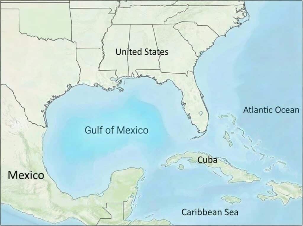
The Gulf of Mexico is the largest gulf in the world and one of the most powerful oceanic regions in world geography. It is almost fully surrounded by the United States, Mexico, and Cuba, and it is crucial to the climate of North America and its economy. The gulf is a huge warm water basin which communicates with the Atlantic Ocean via the Florida Straits and the Yucatan Channel. It hosts a marine biodiversity hot spot and is a source of human activity because its coasts are composed of fertile deltas, wetlands, barrier islands and major river systems.
The geological history of the Gulf of Mexico dates back to over 300 million years due to the movement of tectonics and the gradual segregation of the continental plates. It is now a rich source of off shore oil and gas exploration in the world and a major center of commercial fishing. Its varied ecosystems support millions of migratory birds, sea turtles and marine mammals, thus it is an economic power and an environmental treasure.
Location
- North America
- Bordered by the United States (north), Mexico (west and south), and Cuba (southeast)
Surface Area
- Approx. 1,550,000 km2 (600,000 sq mi)
Key Geographical Features
- Deep central basin with depths over 4,300 meters
- Massive river inflow from the Mississippi, Rio Grande, and others
- Coral reefs, mangroves, estuaries, and barrier islands
- Origin of the Gulf Stream, a major global ocean current
Economic & Environmental Importance
- One of the world’s largest offshore oil and gas zones
- Leading region for commercial shrimp and fish production
- Home to major ports: Houston, New Orleans, Tampa
- Critical habitat for dolphins, whale sharks, sea turtles, and manatees
Interesting Facts
- The gulf is among the most biodiverse marine ecosystems globally, with abundant fish, birds, and marine mammals.
- Extensive wetlands along its shores act as essential buffers during storms and support unique wildlife.
- Human-induced nutrient runoff from rivers has created significant hypoxic zones, known as “dead zones,” in parts of the gulf during certain seasons.
2. Gulf of Guinea
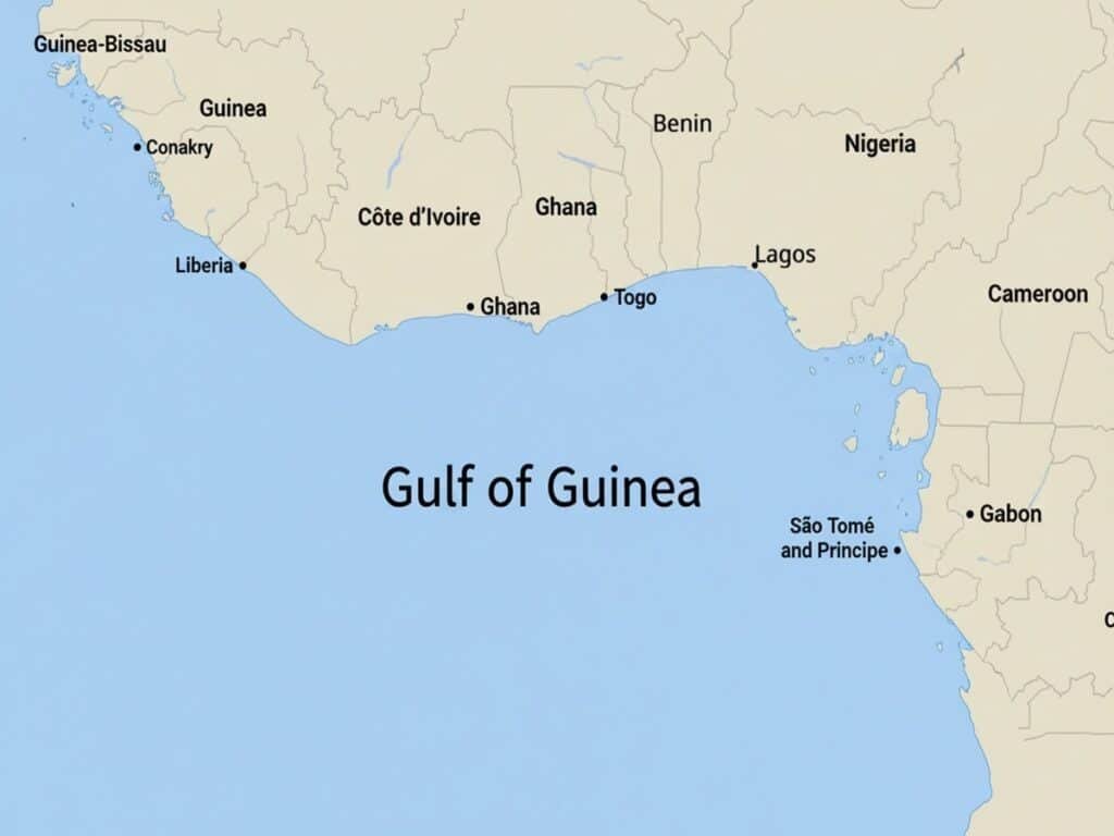
One of the largest and most strategic gulfs in the Atlantic coast of Africa is the Gulf of Guinea. This gulf is a broad, open curve that runs through the western coast of Central and West Africa, through Nigeria, Ghana, Cameroon, Equatorial Guinea, Togo, Benin and the West African country of Sao Tomé and Prinaipe. The geographical location, the proximity to the Equator and the Prime Meridian makes the Gulf of Guinea of special international importance.
The Gulf of Guinea is characterized by a wide range of eco systems which are extensive river deltas, volcanic islands, tropical rainforests, mangrove swamps, and abundant marine environments. Niger Delta is a very important zone in the world as one of the largest deltas in the world, situated at the northeastern frontier of the gulf. Moreover, the oil and gas deposits in the region are so huge that the region plays a leading role in the world energy markets serving as a key contributor to the economy of the West African countries.
Location
- Western and Central Africa
- Borders countries such as Nigeria, Ghana, Cameroon, Equatorial Guinea, Benin, Togo, and São Tomé and Príncipe
- Opens into the Atlantic Ocean
Surface Area
- Basin area approx. 2,350,000 km2 (910,000 sq mi) (widely cited for comparisons)
Key Geographical Features
- Home to the Niger Delta, one of Earth’s most extensive river deltas
- Contains volcanic islands formed along the Cameroon Volcanic Line
- Warm tropical climate with high rainfall
- Coastal zones feature mangroves, lagoons, and estuaries
Economic & Environmental Importance
- One of the world’s leading zones for offshore crude oil and natural gas production
- Hosts major African ports such as Lagos, Port Harcourt, Tema, and Douala
- Supports extensive fishing industries that provide food and income for millions
- Ecosystem rich in tuna, sardines, mackerel, sea turtles, and marine mammals
- Important corridor for regional and international maritime trade
Interesting Facts
- The Equator and the Prime Meridian intersect in the Gulf of Guinea, making it one of the most geographically significant points on Earth.
- During the Age of Exploration, European navigators used this gulf as a key reference point for mapping Africa’s coastline.
- In recent decades, the gulf has been a hotspot for maritime security operations due to piracy incidents and oil theft.
3. Gulf of Alaska
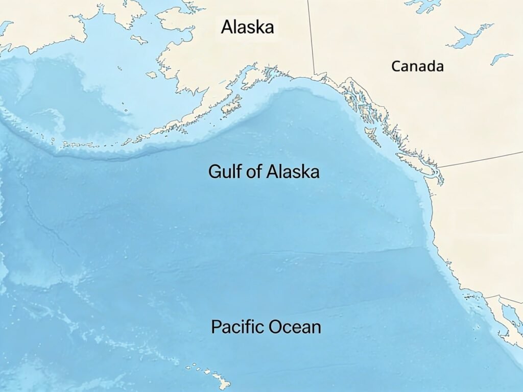
The Gulf of Alaska is one of the most dramatic and ecologically rich gulfs in the world, stretching along the southern coastline of the U.S. state of Alaska. This gulf is famous by its rugged beauty, icy waters and strong storms and is a special interaction of marine, glacial and mountainous environments. The shoreline is covered with towering cliffs, deep fjords, huge glaciers, and some of the finest wilderness of North America. The waters of the gulf are highly productive thereby making it one of the most significant regions worldwide in terms of commercial fishing and marine biodiversity.
The combination of warm Pacific and cold Arctic water bodies form nutrient rich environments which support large populations of fish, seabirds and marine mammals. The gulf of Alaska is also located in a very active tectonic area, which is formed by the motion of the Pacific Plate under the North American Plate. This causes susceptibility of the area to earthquakes, tsunamis, and high-speed geological transformations. The gulf has played a pivotal role in the economy, native culture of Alaska, and the natural ecosystems over the centuries despite its rough weather and remote setting.
Location
- Northern Pacific Ocean
- South of the U.S. state of Alaska
Area
- Approx. 1,533,000 km2 (592,000 sq mi)
Key Geographical Features
- Glaciated fjords and steep coastal mountain ranges
- Influenced by the Alaska Current and subarctic climate
- Contains numerous glaciers, including Columbia Glacier and Hubbard Glacier
- Highly active seismic zone with volcanic and tectonic activity
Economic & Environmental Importance
- One of the world’s major commercial fishing regions (salmon, halibut, cod, crab)
- Important shipping route for Alaskan ports such as Anchorage, Seward, and Kodiak
- Supports diverse wildlife including sea otters, humpback whales, orcas, and millions of seabirds
- Plays a key role in regulating regional climate and marine productivity
Interesting Facts
- Glacial meltwater entering the gulf creates striking turquoise swirls visible via satellite.
- The powerful storms generated here can rival the intensity of Atlantic hurricanes.
- Many of the gulf’s fjords were carved by glaciers during the last Ice Age.
4. Hudson Bay (Gulf-Type Inland Sea)
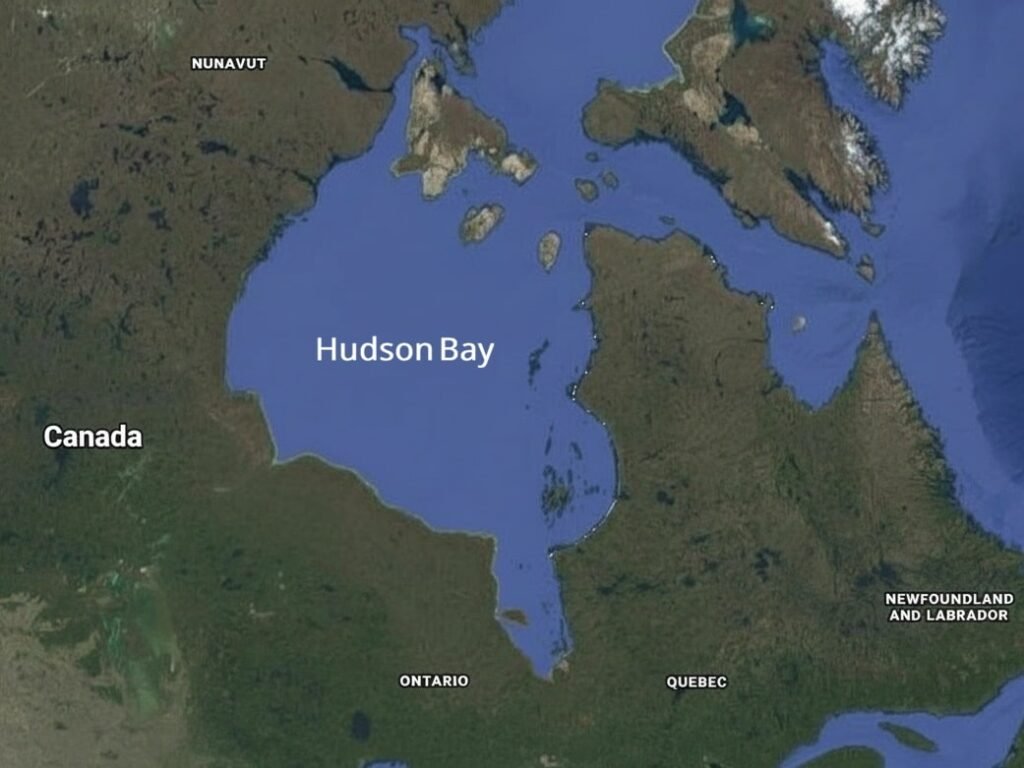
Being officially defined as a bay, Hudson bay is enormous in size and ecological impacts such that most geographers consider it a gulf type inland sea. Hudson Bay is a very extensive feature of brackish water that covers a sizable area of northeastern Canada. It was composed thousands of years ago by melting ice sheets and is located on the huge Hudson Bay Basin- a geological depression that was formed in the past Ice Age. It is a special remote, scientifically important area due to its cold climate, shallow waters, and isolated nature and is therefore useful in the study of Arctic and subarctic ecosystems.
The Hudson Bay is frozen over half of the year and it affects the lifestyle of the indigenous communities and impacts the migration patterns of wildlife. The Hudson Bay Lowlands around it constitute one of the largest wetlands that world has ever known, inhabited by innumerable species of birds, fishes, and mammals. Historically, the bay was the key to the European exploration and economic development of Canada, more so in the fur trade of the Hudson Bay Company.
Location
- Northeastern Canada
Surface Area
- Approx. 1,230,000 km2 (470,000 sq mi)
Key Geographical Features
- Shallow average depth of only about 100 meters
- Surrounded by the massive Hudson Bay Lowlands
- Frozen for 5–6 months annually due to extreme cold
- Brackish water formed by a mix of seawater and river inflow
Economic & Environmental Importance
- Historically significant for navigation and the fur trade
- Important for indigenous communities living along the coast
- Supports marine ecosystems including beluga whales, seals, Arctic char, and polar bears
- A major indicator region for climate change due to melting sea ice patterns
Interesting Facts
- The town of Churchill, along its western coast, is known worldwide as the “Polar Bear Capital of the World.”
- A unique gravitational anomaly in the Hudson Bay region results in slightly lower gravity compared to most parts of the Earth.
- The bay’s extensive wetlands are a major breeding ground for millions of migratory birds.
5. Gulf of Aden
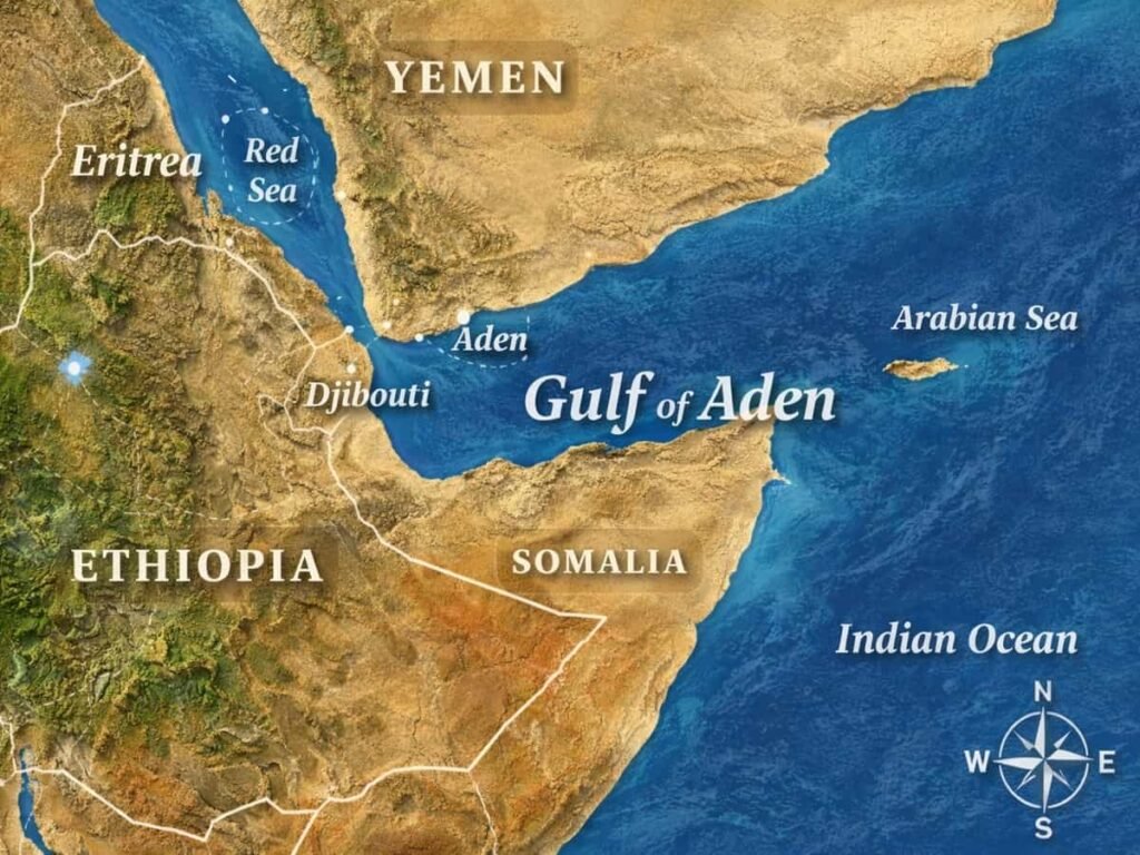
The Gulf of Aden is the world most strategically important gulf as it is a significant maritime route that connects the Indian Ocean and Mediterranean Sea. The gulf is located between Yemen on the Arabian Peninsula and the states of the Horn of Africa, Somalia and Djibouti, and serves as an important passage in the route linking Asian markets to Europe via the Red Sea and the Suez Canal. Since thousands of years, the Gulf of Aden served traders, explorers, and ancient civilizations to exchange spices, incense, gold, textiles and other precious items, and it became a key point in the Indian Ocean trade network.
The gulf is currently one of the busiest commercial shipping routes on the Earth and it has been conducting a massive share of oil transportation in the world and commerce cargo as well. Its deep ocean and distinct ocean currents form very productive marine environment that sustains fisheries and coastal lives.
Location
- Between Yemen (north) and Somalia / Djibouti (south)
- Connects the Arabian Sea to the Red Sea via the Bab-el-Mandeb Strait
Surface Area
- Approx. 410,000 km2 (160,000 sq mi)
Key Geographical Features
- Deep central trough reaching more than 2,700 meters
- Volcanic ridges and rugged coastlines
- Influenced by monsoon winds and seasonal currents
- Contains coral reefs and seamount ecosystems rich in marine life
Economic & Environmental Importance
- One of the world’s most critical maritime trade routes
- Essential for transporting oil, LNG, and cargo between Asia, the Middle East, and Europe
- Supports fisheries—tuna, sardines, mackerel—important for local economies
- Coastal communities rely on the gulf for food, transport, and trade
Interesting Facts
- Ancient civilizations, including those of Yemen and Somalia, prospered by controlling trade in this gulf.
- International naval missions frequently patrol the region due to piracy incidents in the early 2000s.
- The gulf’s waters contain high biodiversity, including dolphins, sharks, and migratory whales.
- Socotra Island exhibits extreme endemism: 37% unique plants, 90% reptiles found nowhere else.
6. Gulf of Thailand
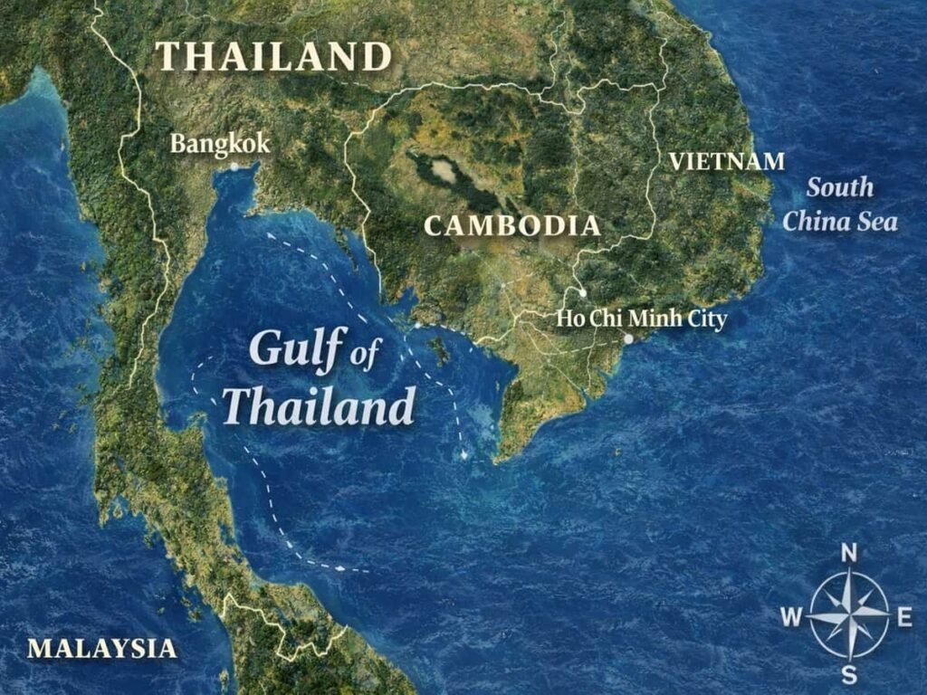
The Gulf of Thailand is a well known and renowned marine area that is very significant in Southeast Asia, characterized by its warm tropical waters, diverse communities along the coast, and rich cultural and economic past. This shallow gulf is the northwestern extension of the South China Sea and is stretched along the coasts of Thailand, Cambodia and Vietnam. The presence of the river in large quantities and its sheltered nature makes it a great fishing ground that serves millions of people.
On the environmental side, the Gulf of Thailand has a significant role to play with regard to the regulation of the climate in the region because it is characterized by a warm sea-surface temperatures and weather systems that are generated by the monsoons. It sustains a variety of ecosystems such as the mangroves, seagrass beds, coral reefs and creates breeding areas of many fish species. The gulf faces pressure due to overfishing and coastal development, even though it is one of the primary regions where conservation activities, marine research, and local maritime collaboration are important.
Location
- Located in Southeast Asia, bordering Thailand, Cambodia, and Vietnam
- Northern extension of the South China Sea
Surface Area
- Approx. 320,000 km2 (120,000 sq mi)
Key Geographical Features
- Extremely shallow: maximum depth around 80 meters
- Receives freshwater from major rivers such as the Chao Phraya, Mekong, and Mae Klong
- Contains islands and coral reefs (Koh Samui, Koh Tao, Koh Phangan)
- Influenced by seasonal monsoons (Southwest and Northeast Monsoon)
Economic & Environmental Importance
- One of Southeast Asia’s most important fishing regions
- Supports shrimp farming, aquaculture, and coastal tourism
- Important for maritime trade and shipping routes in the region
- Coastal cities like Bangkok and Pattaya rely heavily on the gulf for transportation and economy
Interesting Facts
- The island of Koh Tao is one of the world’s leading locations for scuba diving certification.
- The gulf’s warm, calm waters make it ideal for whale shark sightings during certain seasons.
- During the Vietnam War, the United States Navy used the Gulf of Thailand as a major operational zone.
7. Persian Gulf (Arabian Gulf)
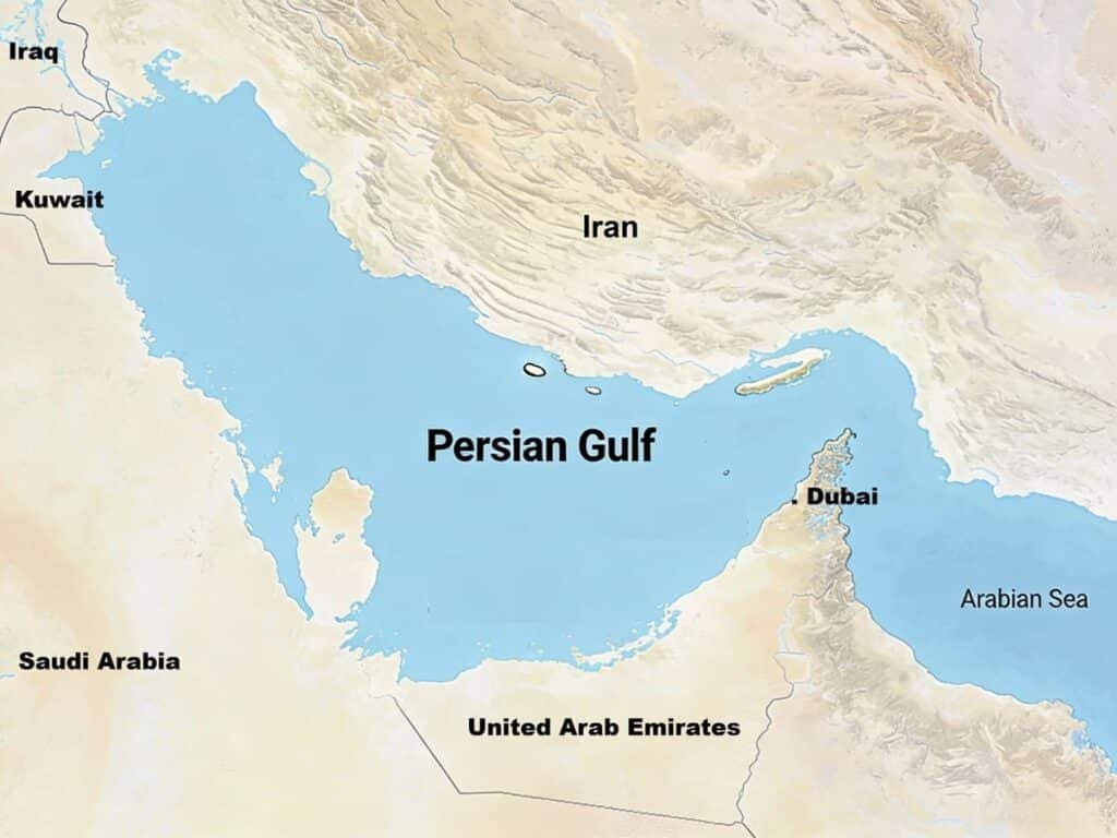
The Arabian Gulf, also referred to as the Persian Gulf, is a relatively one of the most geopolitically relevant marine parts of the world, as well as the largest global energy production center. This shallow gulf is located between the Iranian and the Arabian Peninsula and over thousands of years, the gulf has determined the culture, economic and political life of the Middle East. Due to its huge oil and natural gas reserves, the Persian Gulf is at the center of global trade and energy security, as most of the busiest tanker routes in the world are through its waters.
Geographically and ecologically, the Persian Gulf is a unique region because it has extremely high temperatures and evaporation as well as low inflow of freshwater, which together make it highly saline. The gulf hosts a large number of marine organisms despite these adverse factors; some of these creatures are coral reefs, dugongs, sea turtles, and varieties of fish. The gulf is changing its shoreline into a flourishing area of contemporary facilities, busy seaports and global cities thanks to the rapid coastal development in the countries like UAE, Qatar and Kuwait.
Location
- Located in the Middle East between Iran and the Arabian Peninsula
- Connected to the Arabian Sea via the Strait of Hormuz
Surface Area
- Approx. 251,000 km2 (97,000 sq mi)
Key Geographical Features
- Very shallow: average depth around 50 meters
- Extremely high salinity due to intense evaporation
- Contains numerous islands, coral reefs, and tidal flats
- Receives river inflow from the Shatt al-Arab (formed by the Tigris and Euphrates)
Economic & Environmental Importance
- Contains some of the largest oil and natural gas reserves on Earth
- Major global ports located along the coast: Dubai, Abu Dhabi, Doha, Kuwait City
- Key maritime route for oil and LNG exports to Asia, Europe, and beyond
- Rich in marine biodiversity, including dugongs, sea turtles, and coral reefs
Interesting Facts
- The Strait of Hormuz, the gateway to the gulf, handles around one-fifth of worldwide petroleum shipments.
- The Persian Gulf is home to one of the world’s largest dugong populations after Australia.
- Before the discovery of oil, pearl diving was one of the most important economic activities in the region.
8. Gulf of Saint Lawrence
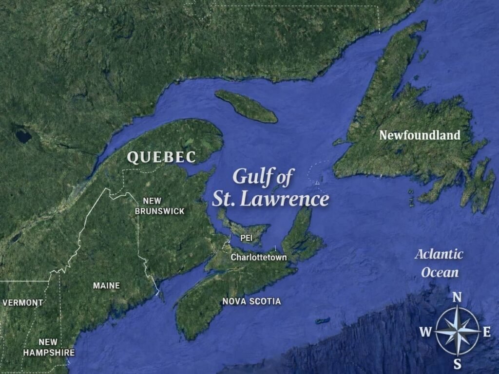
The Gulf of Saint Lawrence is one of North America’s most important marine gateways, serving as the outlet through which the waters of the Great Lakes flow into the Atlantic Ocean. This large semi-closed gulf is bordered by the Canadian provinces of Quebec, New Brunswick, Prince Edward Island, Nova Scotia and Newfoundland and Labrador. It has been the site of history, economy and culture of Canada since time immemorial, starting with the expedits of the ancient European explorers who used the waters to access North America. The Gulf of Saint Lawrence is an important shipping, fishing and tourism center today that links inland ports to the world markets.
The gulf provides a very diverse array of marine and coastal ecosystems, such as cold-water coral habitats, large populations of seals, and feeding areas of many different whale species, in an environmental sense. This is because of its combination of freshwater supplies in the Saint Lawrence River and saltwater supplies in the Atlantic, which provide a unique oceanographic environment, and renders it a key location in scientific studies and environmental research. Ice cover also occurs seasonally in the gulf and this affects the marine navigation, wildlife behavior and climate trends across the region.
Location
- Eastern Canada
- Bordered by Quebec, New Brunswick, Prince Edward Island, Nova Scotia, and Newfoundland and Labrador
- Connects the Great Lakes to the Atlantic Ocean
Surface Area
- Approx. 226,000 km2 (87,000 sq mi)
Key Geographical Features
- Contains major straits such as the Cabot Strait and Strait of Belle Isle
- Mix of freshwater and saltwater
- Numerous islands including Anticosti Island and the Magdalen Islands
- Seasonal sea ice that forms during winter months
Economic & Environmental Importance
- One of Canada’s most important shipping routes for international trade
- Rich fishing grounds with species like cod, crab, lobster, and herring
- Major whale-watching and tourism region
- Home to the Gulf of Saint Lawrence Marine Conservation Areas
Interesting Facts
- French explorer Jacques Cartier entered North America through this gulf in 1534.
- Some areas of the gulf freeze so solidly in winter that ice roads can form.
- The region supports several endangered whale species, including the North Atlantic right whale.
9. Gulf of California (Sea of Cortez)
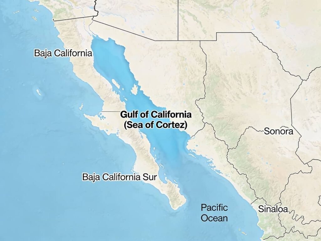
The Gulf of California, also known as the Sea of Cortez, is a marine environment that has one of the richest biologizes in the world. This narrow but deep water body is situated between the Baja California Peninsula and mainland Mexico and has a reputation of beautiful natural sceneries, where the desert mountains plunge down in the turquoise seas. The gulf sustains a spectacular variety of marine life, and as such, it is a quite important ecological treasure to the whole of North America. The Gulf of California has been called a living laboratory by scientists due to its special mix of volcanic Islands, deep basins, coral communities, and migration routes by sea mammals.
The ecological richness of the area aids major fishing sectors, tourist activities as well as conservation initiatives. The gulf forms a severely important breeding and feeding ground to the whales, sea lions, sharks, rays, and thousands of fish species. It is also the habitat of some of the endangered species such as the vaquita porpoise which can no longer be found in any other part of the earth. The gulf along with its islands have been listed as a UNESCO World Heritage Site, indicating the global significance of these areas as far as the environment is concerned.
Location
- Northwestern Mexico
- Between the Baja California Peninsula and the Mexican mainland
Surface Area
- Approx. 160,000 km2 (62,000 sq mi)
Key Geographical Features
- Deep basins reaching over 3,000 meters
- Volcanic islands such as Isla San Esteban and Isla Rasa
- Desert coastline, rocky cliffs, and coral communities
- Seasonal whale migration routes, especially for humpback and gray whales
Economic & Environmental Importance
- Major fishing region for shrimp, sardines, tuna, and squid
- Supports ecotourism activities such as whale watching, diving, and kayaking
- Important for scientific research due to high biodiversity
- Recognized as one of the world’s most productive marine ecosystems
Interesting Facts
- Legendary oceanographer Jacques Cousteau called it “The World’s Aquarium” because of its biodiversity.
- The vaquita, the rarest marine mammal in the world, lives exclusively in the northern Gulf of California.
- Many islands in the gulf were formed by volcanic activity caused by tectonic motion between the Pacific and North American Plates.
10. Gulf of Bothnia
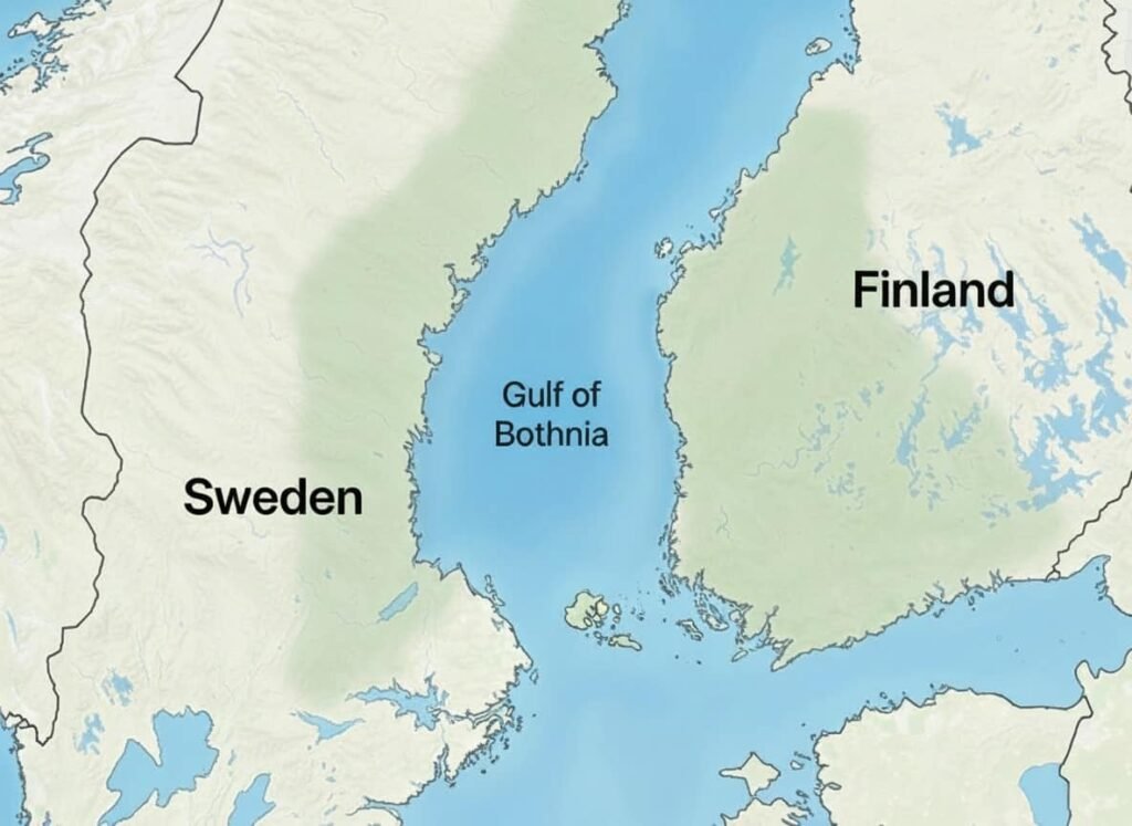
The Gulf of Bothnia is the most northern part of the Baltic sea and one of the largest bodies of water in Northern Europe. It is situated in-between Sweden on the west and Finland at its east, forming a long, narrow and ecologically unique gulf through glacial processes throughout the last Ice Age. The Gulf of Bothnia exhibits a cold climate with low salinity and seasonal sea ice, unlike most warm-water gulfs in tropical and subtropical latitudes, and these characteristics are all of a nature to have a distinctive ecological system. It receives a lot of rivers whose freshwater is injected into the gulf, which have made its waters less salty as compared to most marine environments.
The gulf is split in two parts, the south one being the Bothnian Sea and the north one being the Bothnian bay. All the regions sustain valuable fisheries, forestry-related industries and seafarer trade. The large areas of the gulf are frozen during winter and special icebreaker boats are needed to ensure commercial shipping. The Gulf of Bothnia is a significant part of the economic life of both Finland and Sweden, even though it is characterized by a rather harsh climate: it serves as the route of the transportation process as well as helps support local populations.
Location
- Northern Europe
- Situated between Sweden (west) and Finland (east)
- Northern arm of the Baltic Sea
Surface Area
- Approx. 117,000 km2 (45,000 sq mi)
Key Geographical Features
- Divided into the Bothnian Sea and Bothnian Bay
- Very low salinity due to extensive freshwater inflow
- Covered by sea ice for several months each year
- Geological uplift (post-glacial rebound) continuously reshapes the coastline
Economic & Environmental Importance
- Key route for shipping timber, minerals, and industrial goods
- Supports commercial fishing for species adapted to cold, brackish waters
- Icebreaking vessels are used to keep ports accessible during winter
- Important breeding and feeding grounds for seabirds and marine species
Interesting Facts
- The land around the Gulf of Bothnia is rising by up to 1 cm per year due to post-glacial rebound, creating new islands over time.
- Some coastal areas were underwater just a few thousand years ago and are still gradually emerging.
- The gulf’s unique low-salinity environment supports species rarely found in marine settings.
The largest gulfs in the world are far more than geographic shapes on a map. They contribute to climate of the globe, sustain millions of people, support a rich marine ecosystem, and act as the access to international trade. Each gulf has its own history, as the warm waters of the Persian Gulf are as rich in energy as the icy waters of the Hudson Bay are.
To students and geography lovers, studying these important gulfs will give a better insight into the physical features of the earth and its contribution to the development of human civilization. And to the traveler, most of these gulfs are beautiful in shore, rich in cities, and their natural marvels are never forgotten.